Tag Archive

MAD Lab

Invitation to “Hands On Mapping: Introduction to Tactile Cartography”, 9/7

Invitation to “Hands On Mapping: Introduction to Tactile Cartography”, 9/7

A finger explores a tactile BART system map.

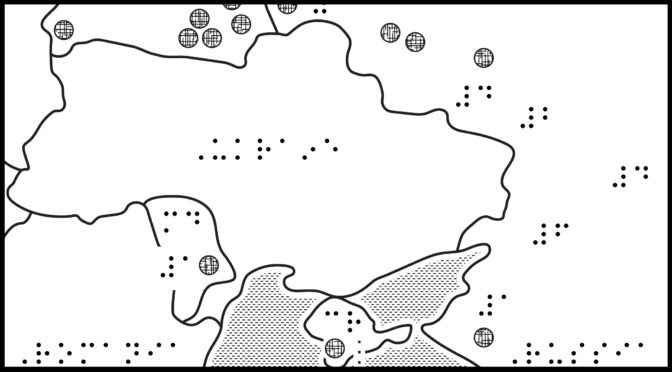
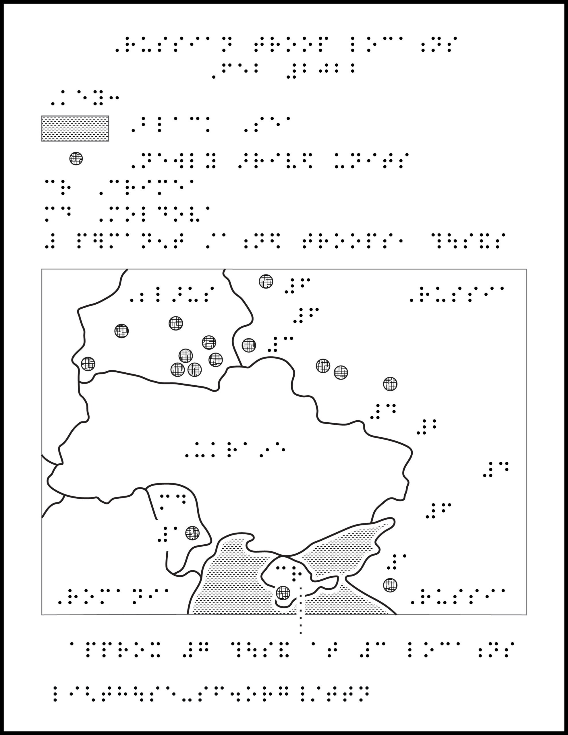
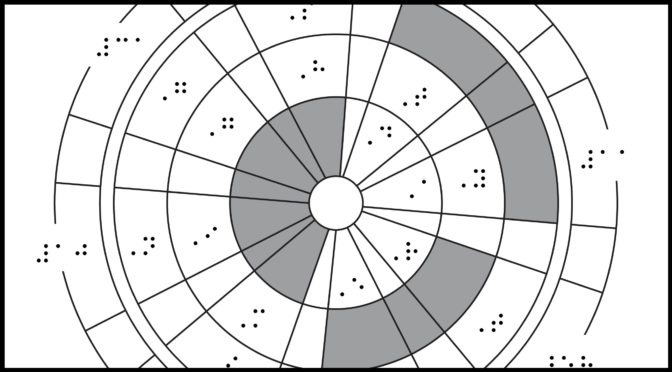
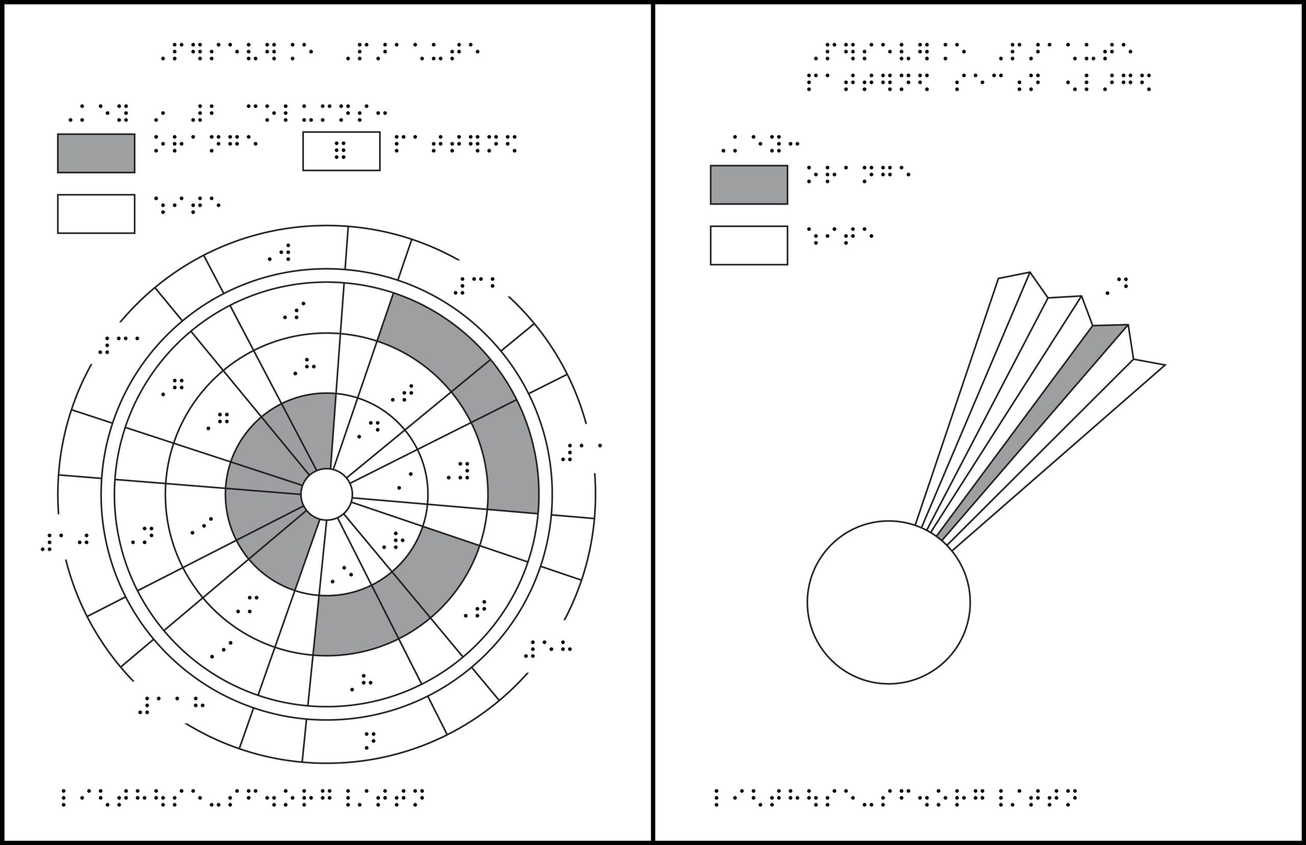
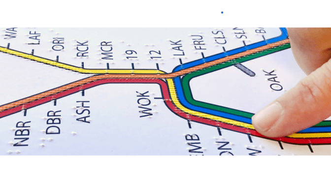
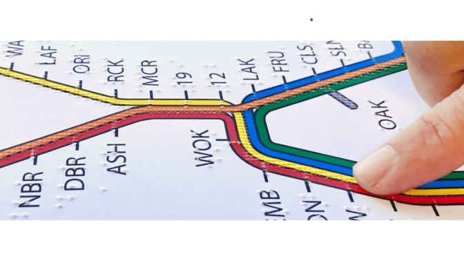
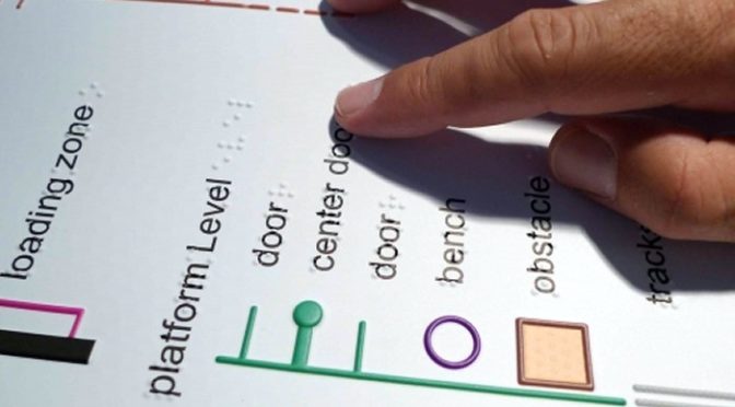
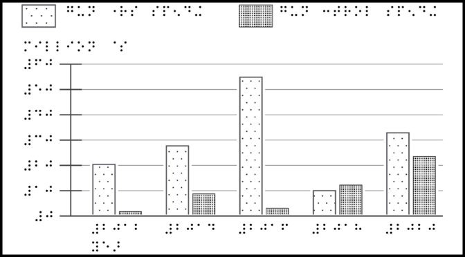
Maps deepen understanding, broaden perspectives, and encourage engagement with our world. However, people who are blind or visually impaired do not have equal access to maps that the sighted population often takes for granted. As one of the few places in the world—and one of the best—producing high-quality tactile maps, the MAD Lab is dedicated to turning inaccessible experiences into inclusive ones.
 
Join the Media and Accessible Design Lab (MAD Lab) for “Hands On Mapping: An Introduction to Tactile Cartography” on Saturday, September 7, from 2:00 pm to 5:00 pm at the LightHouse for the Blind and Visually Impaired, 1155 Market St, 10th floor, San Francisco. 

ASL interpretation will be provided.
 
Getting to 1155 Market Street.

We will introduce how blind people use tactile maps. This event is for all: sighted and blind audiences alike – no prior experience necessary. Whether you are new to tactile cartography or already familiar, you will be warmly welcomed, educated, and thoroughly engaged!
 
Featuring speaker Dr. Joshua Miele in conversation with Dr. Yue-Ting Siu (CATT-NW Program Coordinator, WSSB) and Chancey Fleet (Assistive Technology Coordinator, Andrew Heiskell Braille and Talking Book Library, NYPL), along with a variety of breakout sessions that lead you through the landscape of tactile maps, including:

    • TMAP (Tactile Maps Automated Production). Speakers: Dr. Joshua Miele and Greg Kehret.
    • Reading a tactile map. Speakers: Frank Welte and Jerry Kuns.
    • Designing map symbols using nonvisual tools. Speakers: Chancey. Fleet and Marco Salsiccia.
    • Design a tactile map. Speaker: Naomi Rosenberg.
    • Future of digital tactile maps. Speaker: Mike May.

More info about the event, including agenda, speaker bios and resources can be found at: https://old.lighthouse-sf.org/hom2024.

Food and drink will be served. Entrance is complimentary.

RSVP to Hands On Mapping.

Please share will anyone who you think might be interested.

A Big Thank You to Our Sponsors

The MAD would like to give a very special thank you to our event sponsors WaymoZooxUber, Sharon Giovinazzo and our wine sponsor, Three Sticks Wines of Sonoma.

Waymo – Tactile Titan $10,000 Sponsor

Waymo logo

Zoox – Platinum $5,000 Sponsor

Zoox logo

Uber –  Platinum $5,000 Sponsor

The Uber and Uber Eats logo


Sharon Giovinazzo – Silver $1000 Sponsor

Three Sticks Wines of Sonoma –  Wine Sponsor

Learn the Fundamentals of Using Tactile Maps, March 23

Learn the Fundamentals of Using Tactile Maps, March 23

LightHouse’s Rehabilitation Services and Media & Accessible Design departments are teaming up to present this free course on learning to read tactile maps.
 
This workshop takes place Thursday, March 23, from 10:00 am to 12:30 pm at LightHouse East Bay in the Osher Conference Room. The address is Ed Roberts Campus, 3075 Adeline Street, Berkeley.

What will you learn?

  • The value of tactile maps for route planning and awareness of environmental features
  • Systematic strategies in your approach to exploration of tactile maps
  • How symbols, line types, labels, and distance, direction, and environmental features are used in interpreting maps
  • Tactile discrimination techniques for map reading
  • Greater orientation to new environments
  • How to order more maps
  • In addition to the training, each student will take home free TMAPs of their residential area and of the LightHouse East Bay neighborhood at 3075 Adeline, as well as a tactile map of the Ashby BART Station and a tactile BART system map

Prerequisites:

  • Functional use of intermediate braille is required
  • Students must be aged 16 or up

LightHouse Braille Instructor, Divina Carlson, Senior Accessible Media and Braille Specialist, Frank Welte, Orientation & Mobility Specialist, Sarah McIntyre and tactile map aficionado, Jerry Kuns, will be facilitating this introductory training in the practical use of TMAP, tactile maps and tactile BART maps for Bay Area travelers. It must be noted that Jerry states he isn’t happier than when he has a good cappuccino in one hand and a tactile map in the other!

Come join us in learning the language of tactile maps. To attend, please contact Briana Kusuma, at BKusuma@old.lighthouse-sf.org or 415-694-7335 no later than Friday, March 17. In your email, please provide Briana with your full name, phone number and your residential address, so that we can produce your home map prior to the training.
 
Space is limited to 15 participants. Additional registrants will be placed on a waiting list. We will consider scheduling an additional session if there is sufficient interest. Students may attend with their TVI or O&M teacher. Because this is an in-person activity, we are requesting that you provide proof of vaccination upon entry and wear a mask during the event.
 
This course is made possible thanks to a grant from the Federal Transportation Administration.

Meet with MAD Lab at the Summer 2022 Blind Consumer Conventions

Meet with MAD Lab at the Summer 2022 Blind Consumer Conventions

Members of our Media and Accessible Design Laboratory (MAD Lab) team will be on hand at the LightHouse exhibit booths at this summer’s American Council of the Blind (ACB) and National Federation of the Blind (NFB) conventions. They’ll be showcasing our famous TMAP, which is a tactile street map of a specific area or location as designated by the end-user. Frank Welte will be representing the MAD Lab at the ACB convention in Omaha, Nebraska and at the NFB convention in New Orleans, Louisiana.

If you’re going to the ACB convention, stop by our exhibit booth, say hi to Frank and take a look at a tactile map of Omaha.

Those of you going to New Orleans will find it a bit easier to explore the city because NFB and MAD Lab are working to make copies of a TMAP street map of the area near the convention hotel available, including the French Quarter. Make sure to pick up one of those maps.

Going somewhere else on vacation this summer? No problem! You can purchase TMAP tactile street maps and other unique MAD Lab products at the Adaptations Store. Visit www.adaptations.org or call 888-400-8933 for more information.For inquiries or questions for the MAD Lab, please contact madlab@old.lighthouse-sf.org or visit the MAD Lab page on the LightHouse website. We look forward to meeting you at this year’s summer conferences.

How far will the James Webb Space Telescope see back in time?

How far will the James Webb Space Telescope see back in time?

1. Timeline with 2 circles indicating James Webb Space Telescope and Hubble Space Telescope, and braille labels.

Title: Seeing back into the cosmos

Image description: Graphic illustrating the age of the universe in billions of years relative to how far back human telescope technology can see. The information in the tactile graphic is formatted on a horizontal number line that is logarithmic, with the Big Bang on the left at zero. At roughly 400 thousand years, the cosmic microwave background appears. James Webb Space Telescope can see back to 0.3 billion years when the first stars begin to appear. Between 0.3 and 1 billion years old, the first galaxies are forming. The Hubble Space Telescope can see back roughly 1 billion years. On the far right of the timeline is the modern universe at 13.7 billion years old.

In the original diagram, there is additional information embedded in the background of the number line. In this representation, time is shown as a triangle with the smallest point at the Big Bang. Until the microwave background happens, space is represented by solid orange. Between the microwave background and the time of the first stars appearing is the Dark Age represented by black. There is a thin line of purple, followed by the first stars appearing. This is the beginning of a visual progression over the course of the first stars forming into the modern universe where galaxies are forming tight clusters. When the first stars begin to form, light is diffused progressively aggregating into tight light clusters. At the time of our modern universe, galaxies are bright and forming spiraling shapes.

Download Graphic

ZIP folder contains files for producing tactile graphics on 8.5 x 11-inch paper, landscape:

  • PRNs for ViewPlus Columbia / Delta, APH PixBlaster, IRIE BrailleTrac / BrailleSheet;
  • PDFs for Swell, Microcapsule or PIAF;
  • Reference PDFs with corresponding large print text (not for tactile production).

Printing Instructions and Supported Embossers

How to unzip/uncompress: Windows 10, Windows 8.1, MacOS.

Source: How Far Will Webb See? from Webb vs Hubble Telescope, NASA website.

Related articles: James Webb Space Telescope in final stretch, BBC News; Sharp pictures! James Webb Space Telescope completes alignment in huge milestone, Space.com.

Submit Your Ideas and Touch The News

Sign up

Sign up to receive tactile graphics files to print at home.

Back to Touching The News Gallery

America’s gun culture in charts: gun rights vs gun control spending

America’s gun culture in charts: gun rights vs gun control spending

Bar chart with 5 pairs of bars and braille labels.

Title: Gun Rights vs Gun Control Groups Spending

Image description: Bar graph with y-axis label “million $” and x-axis label “year,” with five pairs of bars comparing gun rights spending as the left bar and gun control spending as the right bar. The y-axis increases from 0 to 60 in increments of 10 million dollars. The year shows years 2012 to 2020. The trend for gun rights spending increases from 2012 to 2016, then decreases with a large dip in 2018. The trend for gun control spending increases from 2012, approaching gun control spending in 2020. Table with approximate amounts below.

Year Gun rights spending (approximate) Gun control spending (approximate)
2012 $20 million  Less than $1 million
2014 $28 million $9 million
2016 $55 million $3 million
2018 $10 million $6 million
2020 $32 million $23 million

Download Graphic

ZIP folder contains files for producing tactile graphics on 8.5 x 11-inch paper, landscape:

  • PRNs for ViewPlus Columbia / Delta, APH PixBlaster, IRIE BrailleTrac / BrailleSheet;
  • PDFs for Swell, Microcapsule or PIAF;
  • Reference PDFs with corresponding large print text (not for tactile production).

Printing Instructions and Supported Embossers

How to unzip/uncompress: Windows 10, Windows 8.1, MacOS.

Source: Chart titled “Gun rights groups have spent more than gun control groups in most recent years” from America’s gun culture – in seven charts, BBC News.

Submit Your Ideas and Touch The News

Sign up

Sign up to receive tactile graphics files to print at home.

Back to Touching The News Gallery

What is the layout of a Major League Baseball field?

What is the layout of a Major League Baseball field?

Baseball diamond layout with braille labels.
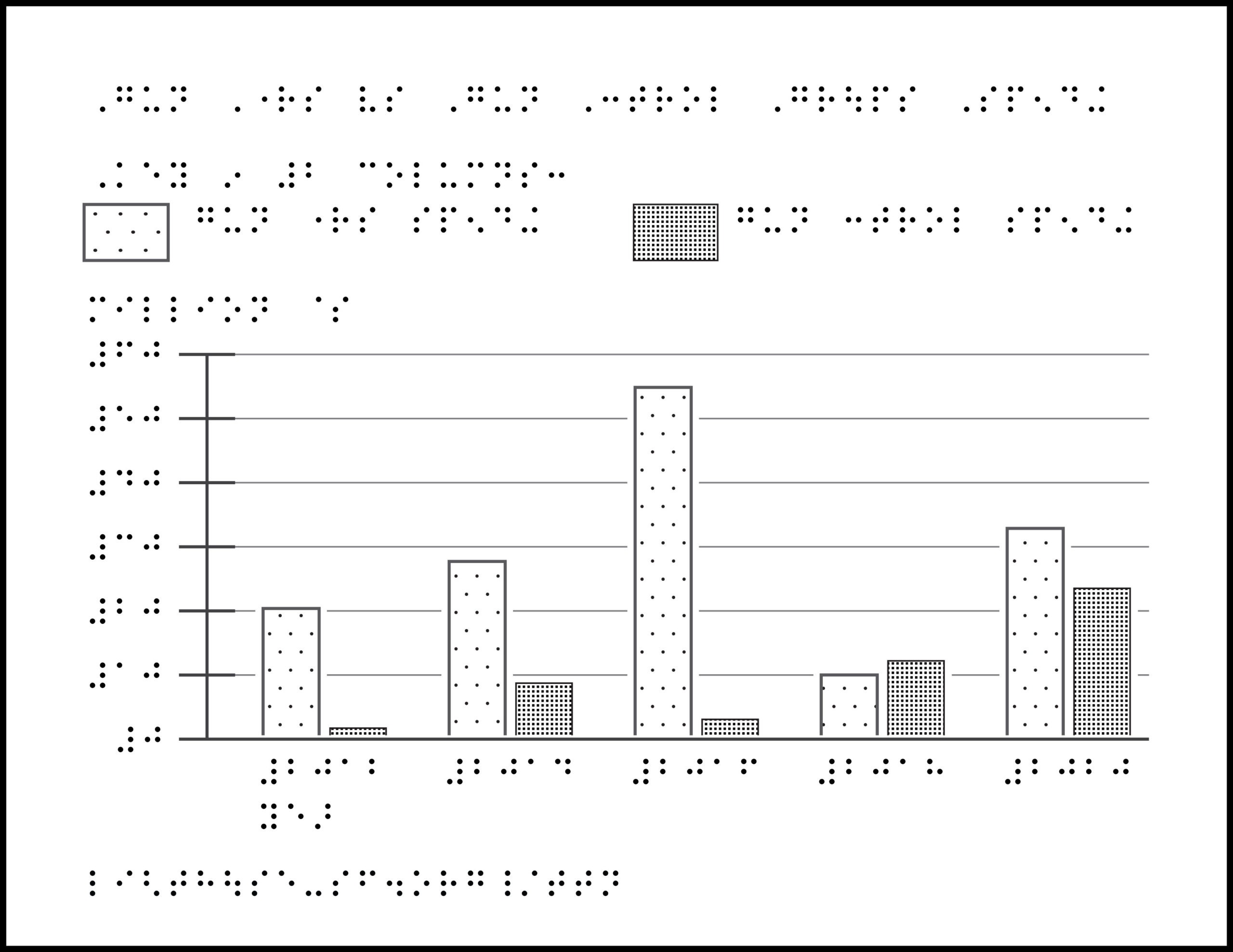
Title: Baseball Diamond

Image description: Aerial view of a Major League Baseball field, with infield at the bottom and outfield at the top. The bases are laid out in a square, rotated 45-degrees, with 90 feet between each, connected by a solid line. Bases are marked by a dot and label, with home plate at the bottom, 1st base to the right, 2nd base above (dotted leader line to label), 3rd base to the left. Foul lines starting from home plate radiate out 45-degrees, represented as dashed lines along the outfield. A small arc connects to the lines beyond 1st and 3rd to show the infield bounds. A large arc connects the top of the foul lines, containing the outfield. Player positions are marked by numbers: 1 pitcher, 2 catcher, 3 first base, 4 second base, 5 third base, 6 shortstop, 7 left field, 8 center field, 9 right field. The graphic includes a key to abbreviations, symbols, and scale line showing 90-ft distance.

Download Graphic

ZIP folder contains files for producing tactile graphics on 8.5 x 11-inch paper, portrait:

  • PRNs for ViewPlus Columbia / Delta, APH PixBlaster, IRIE BrailleTrac / BrailleSheet;
  • PDFs for Swell, Microcapsule or PIAF;
  • Reference PDFs with corresponding large print text (not for tactile production).

Printing Instructions and Supported Embossers

How to unzip/uncompress: Windows 10, Windows 8.1, MacOS.

Related articles: Everything you need to know about ’22 season, mlb.com

Map of Ukraine, relevant cities and regions

Map of Ukraine, relevant cities and regions

Map of Ukraine with braille labels for cities and surrounding countries.


Title: Ukraine Map

Image Description: Map of Ukraine with bordering countries and prominent cities labeled. North is up; north arrow is omitted. Surrounding Ukraine, clockwise from the northeast, is Poland, Belarus, Russia (northeast and east), Black Sea, Moldova, Romania, Hungary (not labeled), Slovakia (not labeled). Crimea is south of Ukraine within the Black Sea, though land adjacent. Cities are labeled with abbreviations, clockwise from the northeast border with Poland: Lviv, Kyiv, Sumy, Kharkiv, Luhansk, Donetsk, Mariupol, Kherson, Odessa. Crimea (south) and the Donbas region (east), are separated with a dotted line.

Download Graphic

ZIP folder contains files for producing tactile graphics on 8.5 x 11-inch paper, portrait:

  • PRN for ViewPlus Columbia / Delta, APH PixBlaster, IRIE BrailleTrac / BrailleSheet;
  • PDFs for Swell, Microcapsule or PIAF;
  • Reference PDFs with corresponding large print text (not for tactile production).

Printing Instructions and Supported Embossers

How to unzip/uncompress: Windows 10, Windows 8.1, MacOS.

Source: Mapping the Russian invasion of Ukraine, Washington Post.

Submit Your Ideas and Touch The News

Sign up

Sign up to receive tactile graphics files to print at home.

Back to Touching The News Gallery

How high was the Tonga volcanic plume?

How high was the Tonga volcanic plume?

Chart with braille labels. X- and y-axis labeling Altitude and Longitude, a horizontal line across the middle with volcanic plume in stratosphere above, and clouds in troposphere below.


Title: Tonga volcanic plume height

Image Description: Chart showing a 2-dimensional view of the stratosphere and troposphere. The y-axis shows Altitude, from 0 to 35 km. The x-axis shows Longitude, from 158 to 162 degrees. There is a horizontal line at 15 kilometers separating the troposphere on the bottom with small, scattered clouds and the stratosphere on top with long, thin volcanic plumes.

Download Graphic

ZIP folder contains files for producing tactile graphics on 8.5 x 11-inch paper, landscape:

  • PRNs for ViewPlus Columbia / Delta, APH PixBlaster, IRIE BrailleTrac / BrailleSheet;
  • PDFs for Swell, Microcapsule or PIAF;
  • Reference PDFs with corresponding large print text (not for tactile production).

Printing Instructions and Supported Embossers

How to unzip/uncompress: Windows 10, Windows 8.1, MacOS.

Source:Hunga Tonga-Hunga Ha‘apai Erupts, NASA Earth Observatory; Tonga volcano: Plume reached half-way to space, BBC News.

Submit Your Ideas and Touch The News

Sign up

Sign up to receive tactile graphics files to print at home.

Back to Touching The News Gallery

Where are Russia’s troops positioned near Ukraine?

Where are Russia’s troops positioned near Ukraine?

Map of Ukraine with symbols and braille labels within bordering countries.


Title: Russian Troop Locations, Feb 2022

Image Description: Map of Ukraine and bordering countries, showing locations of Russia’s troops, both permanently stationed and newly arrived units. North is up; north arrow is omitted. Ukraine is in the middle with Belarus to the northwest, Russia to the northeast and east, Moldova and Romania to the southwest, and Crimea, a small area to the south, surrounded by the Black Sea. Newly arrived units (numbers unconfirmed) are marked with a solid dot. Permanently stationed troops are marked by a number, representing the number in thousands. Near Ukraine, newly arrived units within Belarus: 8; Russia: 6, Crimea: 1; Moldova: 1. Approximate numbers of permanently stationed troops within Russia: 32,000; Crimea: 7000; Moldova: 1000.

Download Graphic

ZIP folder contains files for producing tactile graphics on 8.5 x 11-inch paper, portrait:

  • PRNs for ViewPlus Columbia / Delta, APH PixBlaster, IRIE BrailleTrac / BrailleSheet;
  • PDFs for Swell, Microcapsule or PIAF;
  • Reference PDFs with corresponding large print text (not for tactile production).

Printing Instructions and Supported Embossers

How to unzip/uncompress: Windows 10, Windows 8.1, MacOS.

Source: Map titled “Where Russia’s troops are positioned” within article:Ukraine: What is Nato and why doesn’t Russia trust it?, BBC News.

Submit Your Ideas and Touch The News

Sign up

Sign up to receive tactile graphics files to print at home.

Back to Touching The News Gallery

What was that secret code on NASA’s Mars Perseverance Parachute?

What was that secret code on NASA’s Mars Perseverance Parachute?

2 tactile graphics: Mars Perseverance Parachute with braille labels and detail section.

Tactile graphic 1: Perseverance Parachute

Description: Parachute viewed from below, showing patterned segments filled with orange, white, or a number or letter. The code along the outer circle is the coordinates of NASA’s Jet Propulsion Laboratory in Southern California. The code on the inner rings reads “DARE MIGHTY THINGS,” with the orange-keyed segments spacing out each word.

Tactile graphic 2, detail: Perseverance Parachute, patterned section enlarged

Description: Detail section of one gore (segment) of the parachute, from the center, out to the letter “D,” showing the white and orange pattern in binary code.

Source: Mars Decoder Ring, JPL website.

Additional related articles: NASA Sent a Secret Message to Mars. Meet the People Who Decoded It., The New York Times, Internet sleuths solve secret message on Perseverance rover’s Mars parachute, Space.com, The inspiring hidden message in the Mars Perseverance rover’s parachute, CNN, Mars Perseverance Entry, Descent, and Landing, NASA website.

Download Graphic

ZIP folder contains files for producing tactile graphics on 8.5 x 11-inch paper, portrait:

  • PRNs for ViewPlus Columbia / Delta, APH PixBlaster, IRIE BrailleTrac / BrailleSheet;
  • PDFs for Swell, Microcapsule or PIAF;
  • Reference PDFs with corresponding large print text (not for tactile production).

Printing Instructions and Supported Embossers

How to unzip/uncompress: Windows 10, Windows 8.1, MacOS.

Source: Mars Helicopter Ingenuity Quick Facts, Mars Helicopter Status Updates, Mars Helicopter Ingenuity Fact Sheet (PDF)

Submit Your Ideas and Touch The News

Sign up

Sign up to receive tactile graphics files to print at home.

Back to Touching The News main page