
Title: Russian Troop Locations, Feb 2022
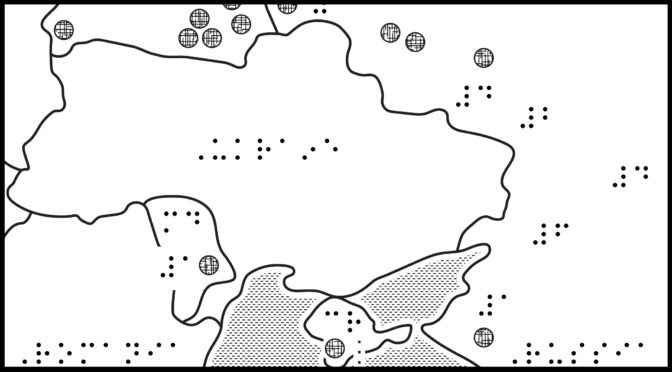
Image Description: Map of Ukraine and bordering countries, showing locations of Russia’s troops, both permanently stationed and newly arrived units. North is up; north arrow is omitted. Ukraine is in the middle with Belarus to the northwest, Russia to the northeast and east, Moldova and Romania to the southwest, and Crimea, a small area to the south, surrounded by the Black Sea. Newly arrived units (numbers unconfirmed) are marked with a solid dot. Permanently stationed troops are marked by a number, representing the number in thousands. Near Ukraine, newly arrived units within Belarus: 8; Russia: 6, Crimea: 1; Moldova: 1. Approximate numbers of permanently stationed troops within Russia: 32,000; Crimea: 7000; Moldova: 1000.
ZIP folder contains files for producing tactile graphics on 8.5 x 11-inch paper, portrait:
- PRNs for ViewPlus Columbia / Delta, APH PixBlaster, IRIE BrailleTrac / BrailleSheet;
- PDFs for Swell, Microcapsule or PIAF;
- Reference PDFs with corresponding large print text (not for tactile production).
Printing Instructions and Supported Embossers
How to unzip/uncompress: Windows 10, Windows 8.1, MacOS.
Source: Map titled “Where Russia’s troops are positioned” within article:Ukraine: What is Nato and why doesn’t Russia trust it?, BBC News.
Submit Your Ideas and Touch The News
Sign up
Sign up to receive tactile graphics files to print at home.